Summer heatwave builds in Prairies this weekend
- NZP Chasers

- Jun 27, 2019
- 2 min read
The Prairies are no stranger to extremes in temperatures. From -40C in the winter to +35C in the summer. The first summer heatwave will impact parts of Manitoba and northern Ontario starting Friday. According to NOAA's National Weather Service,
A period of abnormally and uncomfortably hot and unusually humid weather. Typically a heat wave lasts two or more days.
This will exactly be the case starting Friday. A strong ridge will bring southerly flow into parts of Manitoba for the weekend, which will bring warm/moist air into the region.
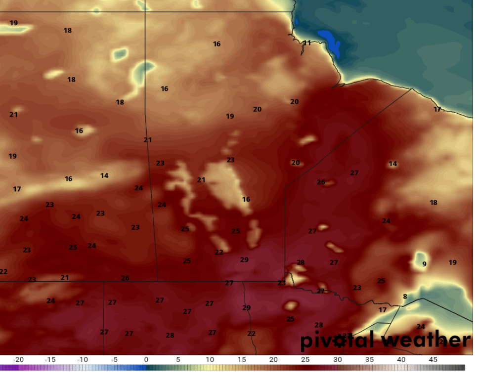
Below are a set of surface temperature maps for Manitoba. These do not account humidex values.
Thursday
Expected temperatures reaching near 30C with over 30 with humidex.
Friday
Expected temperatures reaching over 30C with over 32 with humidex.
Saturday
Expected temperatures reaching over 30C with humidex approaching 40.
Sunday
Expected temperatures reaching near or over 30C with over 30C with humidex.
Why does the air want to kill me?
Well that is a valid question I suppose!! The cause of all this heat and moisture is fairly typical summer pattern for the Prairie Provinces. This pattern is called a "ridging pattern". Below is a graphical depiction of this pattern at the 500MB height in the atmosphere, which is roughly 5.5km high up.
This allows warm/moist air from the Gulf of Mexico to make it all the way up to the Prairies. This pattern may also bring severe weather on multiple occasions starting today, where some significant severe weather is expected in Alberta/Saskatchewan. For that discussion head over here: https://www.nzpchasers.com/post/severe-weather-outbreak-possible-thursday-in-ab-sk
Statements
4:28 AM EDT Thursday 27 June 2019 Special weather statement in effect for:
Cloud Bay - Dorion
Kakabeka Falls - Whitefish Lake - Arrow Lake
The first heat event of the season is expected today. A hot air mass is expected to pay a brief visit to the Thunder Bay area today, with afternoon temperatures near 30 degrees expected. Humidex values may reach the mid thirties. Cooler air from Lake Superior is expected to return by this evening, with temperatures remaining somewhat lower Friday into the weekend. These conditions pose a health risk when you are not used to the heat. Everyone is at risk from heat, especially older adults; infants and young children; and people with chronic illnesses. You are advised to 1) drink plenty of cool liquids before feeling thirsty; and 2) keep cool by dressing for the weather and spending a few hours each day in a cool place.
For the latest watches/warnings: https://weather.gc.ca/warnings/index_e.html


Comments