Double-digit wind chills returning to Prairies this weekend
- Lance Quackenbush

- Oct 15, 2020
- 2 min read
Story by: Lance Quackenbush (@LanceWeatherGuy)
Edited by: Francis Lavigne-Theriault
SKIP TO OUR TEMPERATURE BREAKDOWN FOR A QUICK FORECAST!
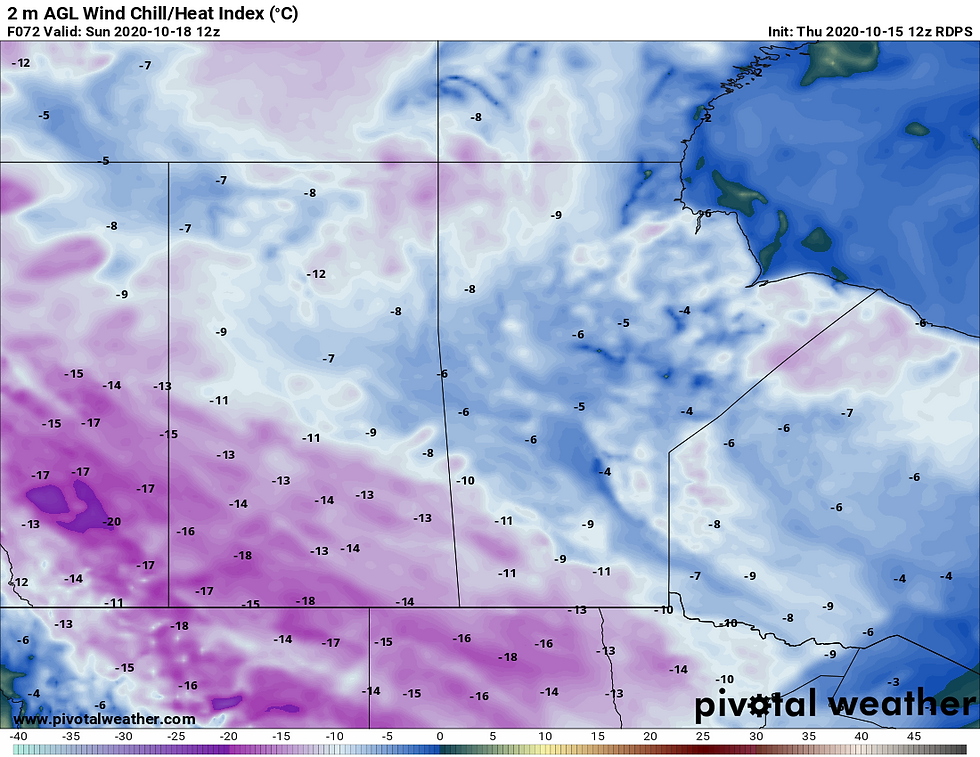
Temperatures will begin dipping below zero tonight and persist throughout the weekend. Temperatures observed below are in the forecast for the Prairies by Friday morning.

A low pressure moving east across Northern Manitoba will bring much colder air through Saturday for the Prairies as shown below. Wind chills will return to Saskatchewan/Alberta/Manitoba.

Daily Low Temperature Breakdown
Saturday October 16, 2020
Winnipeg: -5C / feels like -11
Brandon: -7C / feels like -13
Saskatoon: -2C / feels like -13
Regina: -7C / feels like -13
Calgary: -11C / feels like -15
Sunday October 17, 2020
Winnipeg: -6C / feels like -10
Brandon: -8C / feels like -13
Saskatoon: -9C / feels like -14
Regina: -9C / feels like -13
Calgary: -10C / feels like -13
Technical Discussion
A stagnant early winter setup is expected for Western Canada over the next week as a strong ridge over Greenland will lead to a corresponding trough in the jet stream for the region.

Instead of progressing east, the strong Greenland ridge will block the cold air from getting to Eastern Canada, and an area of low pressure will be trapped over the Northern Manitoba/Hudson Bay region cycling down cold arctic air from Alberta to Northern Ontario, where temperatures will be 5 to 15 degrees below normal.

Cold air and a northwest wind will also trigger some lake effect snow off Lake Winnipeg in Manitoba today into Friday for areas east of the lake. (For more info on the lake effect snow potential, see https://www.nzpchasers.com/post/colder-air-to-bring-lake-effect-snow-to-parts-of-manitoba).
The resulting cold air will bring some bone chilling wind chills and temperatures, mainly to the Prairies. Across Alberta and Saskatchewan, the mercury will not rise above the freezing mark this weekend, with highs in southern Manitoba getting no more than a couple degrees above zero.

This is a far cry from normal where typically highs would be in the lower double digits across Southern Manitoba, Saskatchewan and Alberta. Nighttime lows will also be frigid for this time of year, with overnight temperatures falling below -5 in many regions, with some areas in Alberta reaching near -10 this weekend. Winds will generally be light, however wind chills below -10 to -15 will be frequent across Saskatchewan and Alberta where base temperatures will be the coldest.

Temperatures look to rebound some for the region going into the middle of next week, however temperatures will still remain well below normal as the ridge over Greenland looks to bottle up the cold air for at least a week, and the cold anomalies continue towards the end of the month.


Kommentare